 |
 |
July
21, 2005: Onward, to the Falls of Tarf |
||||||||||||||||||||
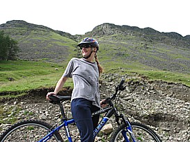
After a grueling morning of deep background research, we drove up to BaseCamp Bikes, a bicycle hire run out of The Firs B&B in Blair Atholl, Perthshire. BaseCamp recently changed hands, and the new owner, Geoff Crerar, is a great guy who made us feel like the elite, pampered cyclists we've always dreamed about being.
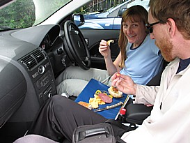
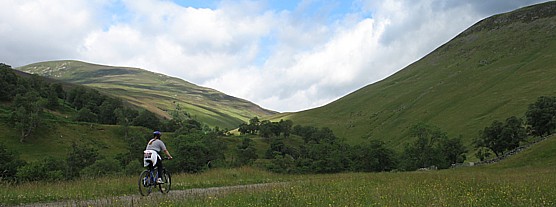
Unlike every single American establishment that I've ever rented bikes from, BaseCamp had an entire stable of new, well-maintained mountain bikes in a wide variety of sizes. There were children's mountain bikes, soft-tails, hard-tails, hybrids, bike trailers, the works. Also unlike American bike rental places, Geoff did not nickel and dime us, or, pence and schilling us if you will, for the extra gear we needed for a safe and enjoyable ride. For £18 pounds, we got two hard-tail mountain bikes for a half-day, along with helmets, a security lock, pumps, a spare tube, a field toolkit, and a route map. The bikes were in great shape. We were riding new Trek 3900 hardtails (JB: 15", Cannonball: 21.5") with new tires. The brakes worked great and the shifting was finely tuned. My only complaint was that the bikes were not set up for aggressive trail riding. Each bike had a very short, 15-degree stem, and my bike had a stack of four headset spacers. This made for a very comfortable ride, but because the geometry had the handlebars sitting up so high, the bike handled pretty skittishly in the technical stuff. The platform pedals with no toe clips also made it difficult to negotiate the technical sections. This is all nitpickery though, because, as I've mentioned, Geoff's bikes were way better than any bikes I've ever rented in the U.S. (See October 21, 2004: Austin city limits) After procuring the bikes and scouting out our route up the Tilt River Valley to the Falls of Tarf and its attendant suspension bridge, JB and I dined on salami, cheese, and bread in the team car. Excitedly, we wolfed down the feed and then changed into our cycling gear. Actually, the only cycling-specific bike gear we brought were our chamois shorts, but we had plenty of moisture-wicking exercise clothes and our trail-running shoes, so we were fully prepared to comfortably tackle some Scottish trailage. We set off at about 3:00 p.m., for what all the locals informed us would be about a four-hour ride to the falls and back. (The Perthshire Tourist Board cautions "allow up to six hours. -- Hard"*) Everybody we talked to about this ride seemed very surprised that we were attempting it, and, to a person, they cautioned us on how steep it was and how much climbing we'd have to do. Suffice it to say, I humored them with lots of "oh yeah, really? That sounds tough alright. We'll take it slow," but inside, I scoffed at their tall tales and admonitions.
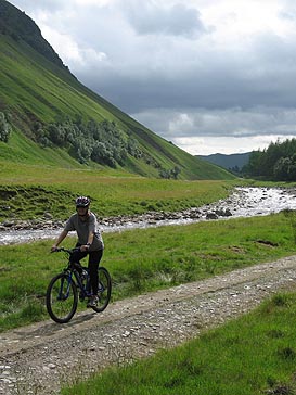
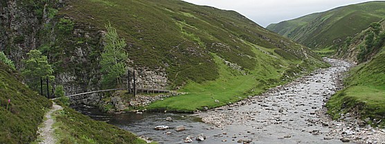
I mean, we're not Jerome and Kitty Wilfe from Blunderbuss, Nebraska here. Do we look that old, infirm, or out of shape? I think the issue at play was less us than it was the fact that mountain biking hasn't really caught on here yet. As I mentioned previously, Scots are proud trekkers; they love to walk (See July 20, 2005: Moab, Kamloops, . . . Perthshire?). On the other hand, trail biking is on the fringes of the public consciousness, but hasn't fully been acknowledged yet. Over the course of my travels through Scotland thus far, I have seen a handful of beater department store mountain bikes, maybe half a score of downhill/freeride mountain bikes, and only two or three serious cross-country rigs. So while the Scots can relate to the idea of a 30-mile trek, the idea of a trail ride of similar length seems as cracked as the idea of invading another sovereign country and forcefully deposing it's leader as an act of self defense. Turns out the toughest part of the ride was finding the trailhead. Starting from the village of Blair Atholl, our mappage advised us to head west out of town and pick up "the unclassified road signposted Old Blair & Monzie, up to the old Bridge of Tilt." We made this part OK, however, from the old bridge, our directions read, "after cycling 50 yards turn right onto the Landrover track and into Glen Tilt." We rode about 50 yards from the bridge and came across a gated Landrover track with the sign "Private Drive -- OK to enter." Here's where our American frames of mind led us astray. We saw "Private Drive" and immediately determined that we couldn't use the road. This false premise sent us off on about a 15-minute wild-goose chase until we finally compared our topo map to the terrain around us and figured out that the Private Drive was the only to access Glen Tilt. We started gradually climbing up a well-maintained Landrover track (gravel road/graded fire road), following the undulating gradient along both sides of the Tilt River. Yes, we were climbing, but at an angle so gentle as to invite an aggressive pace. This was a climb to be attacked, not dreaded.
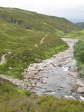
Pedaling steadily, we passed numerous cottages and ruins, as well as some mapworthy landmarks such as Gilberts Bridge and Forest Lodge. A strong, gusty wind was at our backs, which made the climb that much easier, and the idea that we were mountain biking on a different continent added a couple extra RPMs to our pedal strokes. The Tilt River was the color of single malt whisky, and the treeless hills were the color of fine Scottish Kush. Occasionally our solitude and wonder was rudely disrupted by extremely low-flying military fighter jets practicing low-altitude maneuvers in the valley. I mean, they were flying really, really low -- below the ridgelines of the valley low. When I did Outward Bound in Joshua Tree when I was 16, I saw US Marine jets out of 29 Palms doing the same thing. When you see a fighter jet flying that low, that fast, right over your head out in the middle of nowhere, it's a little unnerving. In addition to the jets, there were lots of sheep milling about the roadway. Unlike cows, sheep are somewhat skittish and most of the time they'd take off running when we approached. That was fine when we were pulling 10-15 MPH climbing, but on the return trip coming down the hill, there were a couple of times when they nearly got underwheel. What we didn't see was any Scottish thistle. I see more of that devil weed in one ride in EG than I have on this whole trip. I guess the national flower of Scotland is America's problem now. Just after Forest Lodge, a nice little B&B tucked in a grove of pines about 10 miles up the Landrover track, the trail started to get rocky and a little boggy. JB decided to turn back, while I vowed to push ahead to the falls. Knowing how easily I can get distracted by shiny objects and interesting trail spurs, JB challenged me to make it up to the falls and then overtake her before she made it back down to the bottom of the hill. I knew I'd never catch her, but I wanted to take a shot at the falls, so I said yeah, sure.
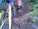
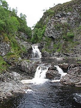
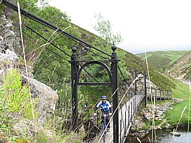
I guestimated that I had about five miles to go to reach the falls, so I gave myself 30 minutes. Unfortunately, the trail got increasingly rougher and tougher to hammer on platform pedals. About 3.5 miles from where I left JB, the trail split, with the left fork heading steeply up to the ridgeline and the other heading right along the river. The map said take the right fork, but I would have dearly loved to tackle that ridgeline ascent. After 25 minutes, I was beginning to lose faith. I knew I couldn't go on much longer without making JB wait for a long time down at the bottom of the hill. Just as I was about to turn back, I sighted a large escarpment about a mile up the left side of the valley. I knew that had to be where the Tarf River fed into the Tilt, so I pushed on. About a half mile out from the escarpment, the trail turned from rutted doubletrack to very rocky, undulating singletrack. Yeah baby! I've said it before and I'll say it again, singletrack is where you find it, and you can almost always find it if you try hard enough. At the bottom of one particularly rocky, rutted slope, I came to a very large mud puddle that spanned the entire trail. The puddle looked deep and the mud surrounding it looked thick and sludgy. The right side of the puddle was bordered by a large boulder and the left side was guarded by a withered shrub. In a split-second decision, I took a line through the withered shrub. Only, I had slowed to give myself time to pick a line as I approached the puddle, and as I stood on the pedals to pull through the muddy apron leading up to the shrub, I became bogged down in the mud and came to a complete stop. Riding an improvised track stand, I reached out for the shrub with my left foot, but whiffed and felt my center of gravity slowly moving right toward the puddle. Like a stately old-growth Redwood falling to the mighty drag chain, I completed timmm-berrr-ed straight into the puddle, the very puddle I had been trying to avoid. I was soaked, muddy, embarrassed, but there was nobody out there but us chickens.
Just past the puddle, the suspension bridge came into view. I was there! JB and I had separated at 4:20, and it was 4:55 when I rolled across the bridge over Tarf Water at the bottom of the Falls of Tarf. I snapped a couple of quick pictures then swung around and set off in pursuit of JB. I hammered as hard as I could, but the headwind, the lack of riding, and the high-profile bike conspired to slow my progress. I also lost time to some picture taking and a minor mechanical. For some reason, on the descent, the seatpost clamps kept coming loose. I stopped twice to tighten them, but each time they came loose again within a few pedal strokes. To avoid losing the seat altogether, I rode the last five miles standing up. There is precedent for this: a couple of years ago, I broke my seatpost at the bottom of Mt. Tam and ended up doing the whole climb to the top, the descent, and the rest of the 25-mile ride pretty much standing up. Huffing and puffing, I rolled into BaseCamp at 5:57 -- the fifteen-mile return trip had taken me just 57 minutes! JB had pulled in at 5:45. I knew I wasn't going to catch her, but the element of pursuit was pretty fun. Romulus and I should think about working some pursuits into our training regimen. So after a ride like this, less than 50 miles from Gleneagles, I ask again, the best ride Bush could come up with was a spin around a golf course? on pavement? Fine for a weekend duffer, but isn't Bush supposed to be Mr. MTB badass? I guess the rock doesn't fall far from head. Like President Bush, it appears that Cyclist Bush is not interested in exploring the unexplored; instead, he is satisfied to stick within the narrow confines of his comfortingly familiar bubble.
It's his loss. Scotland is a great country for mountain biking, if you care to find out. *Cycling & Mountain Biking in Perthshire." Perthshire Tourist Board. 2005.
|

| Mileage: ~30.0 | Time: ~2:40:00 | Avg: | Max: ~25.0 | Weight: |
Got
a comment or question? Send it to truthmaker24@yahoo.com. |
||
-- Amalgamated TruthMaker Enterprises --